History of Google Street View / Tunisia

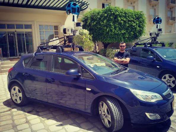
Google started driving for the first time in Tunisia around July 2016, where Dutch cars were transported from France to Tunisia. The decision to integrate Tunisia into Google Street View started in 2014 when the American company began the process of talks with the Tunisian government, Following a wave of insecurity in 2015, the Ministry of Defense suggested to Google that part of the Street View cars be accompanied by a security car, to ensure that as much as possible could be photographed without compromising the safety of the driver or the condition of the photographic equipment.[1]
A total of two cars were transported, one destined to cover the Tunis area and several cities in the north such as Sousse, Nabeul and Bizerte, and the second destined to cover the south of the country starting from Djerba Island to Sfax and Gabes.[2]
The Google Street View introduction project was led by Sami Ghazali, between December 2015 and April 2016, around 15 meetings were held between Google and the Tunisian Ministry of Interior and Defense. In March 2017, Google published the first coverage in Tunisia.[3]

The project was supported by the National Heritage Development and Cultural Promotion Agency in addition to the National Museum of Bardo, where several views of state museums and archaeological sites were published using trekkers, tripods and special trolleys.[4]
The Google team had planned to cover many more cities in the north and west of Tunisia such as Tozeur and Gafsa, although the filming of these cities was not done before the time limit and no official response has been given about it.[5]
The Street View project started in two parts in the country, including some areas in Tunis in addition to the Djerba Island in the Governorate of Medenine, where a vehicle was initially sent to the Djerba-Zarzis Airport located in Mellita from mid-July 2016 in order to photograph the roads of the island although the filming process had to be delayed due to damaged photographic equipment.[6]
The project was also supported by the University of Tunis El Manar for digitization of campus facilities through the use of trekkers and indoor tripods.[7]
History
Note: We take into account the date when the coverage was taken, not the date when it was published.
Source: Tunisia's Coverage Dates - Emily Geo Website
| Year | Additions |
| 2016 |
|
| 2017 | Landmarks in Gafsa, Al-Kāf and Maktar |
Gallery
Trekker
Note: Many thanks to Mohamed Farrah for supplying us with a photo of the Google Trekker at the University of Tunis El Manar.
Gen 3 Cameras
External Resources
- Tunisia at Google Street View Cars Mapped
References
Naffati, W. "Google Street View débarque en Tunisie" (2016) Tunisie Haut Debit. (in French)
"Les voitures de Google Street View parcourent nos rues (vidéo)" (2016) MosaiqueFM (in French)
Fehri, N. "Google Street View en Tunisie : Un exemple de collaboration Public, Société civile et diaspora" (2017) Leaders.tn (in French)
"Visites Virtuelles de la Tunisie Google Maps-Street View" The National Museum of Bardo (in French)
"Les voitures de Google Street View parcourent nos rues (vidéo)" (2016-07-13) Mosaique.fm (in French) Quote: "Les deux voitures se dirigeront ensuite vers Tozeur, Gafsa et les villes du Nord-Ouest et reviendront dans quelques mois pour réaliser un travail plus minutieux."
"Djerba : La caméra de Google Street View tombe en panne à cause de l’état de la route" (2016-07-14) DirectInfo (in French)
"L’Université de Tunis El Manar et ses établissements parmi les sites choisis par Google pour le projet Google Street View Special Collect" (2017-07-24) Université de Tunis El Manar (in French)


