History of Google Street View / Oman
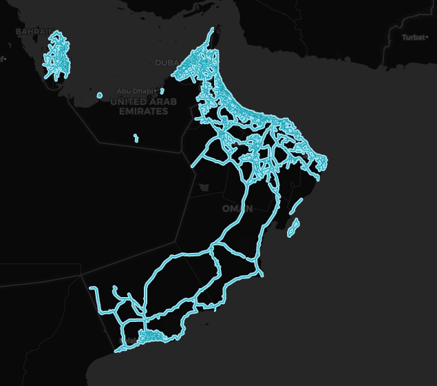
(Source: SV-Map)
At the end of February 2024, Google officially announced that it was going to introduce the street view project to the Sultanate of Oman.
The project was supported by the Ministry of Transport, Communications and Information Technology (MTCIT) and the National Survey Authority with the objective of covering a large part of the country between 2024 and 2025.[1] The initial phase of the project focused on introducing street view to most of the suburbs in the metropolitan areas of Muscat, Sohar and Salalah.[2]
In mid-November 2024, Undersecretary of the Ministry of Transport, Communications and Information Technology, Ali Al Shidhani announced the availability of the Street View project around the Sultanate in order to improve navigation.[3]
Muscat Governorate
The first Gen 4 Pickup tests in the country started around Ruwi (Arabic: روي), the financial center of Muscat at the end of February 2024. Although coverage of certain areas was not published due to security reasons such as the area around the National Defense College (Arabic: كلية الدفاع الوطني) and the Sultan Armed Forces Museum (Arabic: متحف قوات السلطان المسلحة). In addition, panoramas were also taken around the mountainous area of Sidab (Arabic: سداب) near the coast.
Between March and April 2024, a large part of the Muscat surbubs were covered. Later, coverage was expanded to cities surrounding Muscat such as Seeb, although certain areas of the city had to be excluded for security reasons, such as Al Murtafiah (Arabic: المرتفعة) and the areas around Muscat International Airport. In addition to the Al Amarat metropolitan area was also covered at the beginning of March.
From this point on, Gen 4 Pickups began to circulate in more rural areas in the governorate, covering such scenic spots as Bandar Al Khairan Viewpoint (Arabic: وجهة نظر بندر الخيران) photographed in March 4, Wadi Al Maih (Arabic: وادي الميح) in March 7. In early June, the Google Maps team in Muscat traveled to much more rural areas, covering several wadis such as Wadi Hammam (Arabic: وادي الحمام) and the Wadi As Asrin Natural Reserve (Arabic: محمية وادي السرين).
Al Batinah Region
The first images recorded in this part of the country were at the end of February in the metropolitan area of Sohar, capturing historical sites of the city such as the Sultan Qaboos Mosque (Arabic: جامع السلطان قابوس) and the Sohar Fort (Arabic: قلعة صحار) located in the coastal area. Most of the Sohar metropolitan area was covered, with the exception of the area around the Al Batinah North Governorate Offices (Arabic: مكتب محافظ شمال الباطنة).
In the middle of May, Google Maps vehicles began navigating around the mountainous area of Al Batinah North Governorate, photographing the areas of Wadi Al Haimli (Arabic: وادي الحيملي) located in the Wilayah of Rustaq and Wadi Aljahawar (Arabic: وادي الجهاور).
In early July, Google vehicles covered part of the Wadi Al Maawil Wilayah located in Al Batinah South, the coverage mainly extends between the urban areas of Afi (Arabic: افي) and Hibra (Arabic: حبراء), in addition to covering important cultural sites such as the Al Ghasham Museum House (Arabic: متحف بيت الغشام).
Subsequently, in the middle of the same month, the vehicles began to cover part of the Shinas Wilayah, covering the historical area of the region capital including views of the fort located in the Shinas Souq (Old Market), these vehicles also covered small towns in the region, photographs of historic sites were taken such as the Ajib Castle (Arabic: حصن عجيب). At the end of July, the Google cameras traveled to new areas of Al Batinah North, specifically around Wadi A'Sarmi (Arabic وادي الصرمي) located in the Wilayah of Al-Khaburah.
In early August, vehicles began to tour the Barka and Al-Musannah metropolitan areas as well as coastal towns in these Wilayah, the Google Maps equipment took panoramic views around the Al Sawadi Beach Park (Arabic: حديقة شاطئ السوادي. In addition, photos were also taken of monuments such as the Sawadi Fort (Arabic: سور الحكمان) and the Al Musanaah Castle (Arabic: حصن المصنعة). Also in this month, the Google Maps team also covered rural areas in the mountainous area of Al Batinah North such as Wadi Al Jizzi.
In late August and early September, Google began to tour the Wilayah of Al Suwayq, the mapping team took photographs around As Suwayq Castle (Arabic: حصن السويق) near the city's port. The coverage was also extended to small historical towns full of archaeological ruins such as Mashayq which has a complex of Ancient Houses (Arabic: قرية مشايق بني خروص)
Ash Sharqiyah Region
At the end of June 2024, Google's mapping team began to cover much of the area around Dima Wattayeen, characterized by a mountainous area where it crosses several water sources such as Wadi Al Khabbah. Additionally, the Google Maps team also sent a trekker to Masirah Island located in the eastern part of the country. Coverage on the island extends mainly around Ras-Hilf Port.
In early August 2024, Google began introducing street view to the mountainous area of Ash Sharqiyah North Governorate, where several scenic roads were covered including the Al Sail Viewpoint.
By the end of September 2024, coverage was gradually expanded around the Ash Sharqiyah South Governorate, including imagery around most of suburbs in the city of Sur.
Dhofar Governorate
In late March 2024, Street View vehicles began navigating around the Salalah metropolitan area covering much of the suburbs although like other areas in Oman, all coverage near government facilities has been blocked as well as images near Salalah Airport. This was the first images taken in the Dhofar Governorate. Starting in April, Google Maps equipment traveled to rural areas around Salalah covering natural reserves such as the Ain Sahlounout Springs (Arabic: عين صحلنوت) and the Ain Garziz Garden (Arabic: عين جرزيز) as well as views around the course of the Wadi Darbat.
Later in May, several nature reserves were photographed around the the Ain Athum (Arabic: عين أثوم), Ain Hamran (Arabic: عين حمران) and Ain Tabrok (Arabic: عين طبرق) waterfalls.
Al Buraimi Governorate
Google Street View vehicles traveled to the metropolitan area of the capital of the governorate at the end of March 2024, although much of the coverage is unpublished for security reasons, specifically the sectors near Al Ain on the UAE border.
By May 2024, Google cameras had traveled to the northern part of the governorate including desert areas around .
In September, coverage was gradually expanded around several areas of the governorate including views south of Jebel Hafeet (Arabic: متنزه جبل حفيت), a range of mountains extending from UAE to Oman. Other scenic spots recorded in this governorate also include the Wadi Ajran (Arabic: وادي اجران) located in the southeastern corner of the region.
In the same month, Street View vehicles also focused on introducing street view around the Wilayah of Mahdah, including mountainous areas such as the road that connects to the Wadi Al Jazira (Arabic: وادي الجزيره), this road often reaches an altitude of over 700 meters and it is located remote area in the governorate. Other mountainous areas covered by Street View in this governorate also include Jabal Al Hayl (Arabic: جبل الحيل) located north of the Mahdah metropolitan area. In addition, images from the north of Al Buraimi were also captured, including Jabal As Sumayni (Arabic: جبل السميني) and Wadi Mayhah.
Ad Dhahirah Governorate
The first attempts to introduce street view to Ad Dhahirah began in mid-May 2024, where most of the main highways were covered including areas within desert zones such as Fahud as well as views of the road connecting the governorate to Saudi Arabia.
Although much of the governorate's coverage did not include many rural areas as well as sidestreets in the first release of Google Street View in Oman, it was only until early September that the Google Maps team drove into much more areas in Ad Dhahirah, covering quite a few suburbs around Ibri.
In late September, mapping equipment arrived in the area around the Tawi As Sayh Valley (Arabic: طوي السيح), covering part of the nearby wadis. In addition, mountain roads in the Wilayah of Al-Awabi were also covered as well as views around the As Susud Mountains (Arabic: السدود).
Ad Dakhiliyah Govenorate
In early September 2024, Google began photographing many mountainous areas in the governorate such as the road that connects to Jabal Akhdar, one of the few roads in Oman covered that passes at an altitude of over 2400 meters.
By mid-September 2024, Google began touring the Nizwa metropolitan area, where the mapping team photographed city landmarks such as the Aswiq Historical Village (Arabic: حارة السويق القديمة، ولاية نزوى), Alqarn Tower and Falaj Daris. Additionally, Google Maps began to expand coverage around the Saiq Plateau.
Musandam Governorate
At the beginning of July 2024, Google sent a pickup to this governorate, this region is characterized by being separated from Mainland Oman by UAE. Although much of the coverage in this governorate is very limited and only the coastal road connecting Tibat to Khasab was covered.
Some important historical sites were covered along the way such as the Bukha Fort.
Removed Coverage
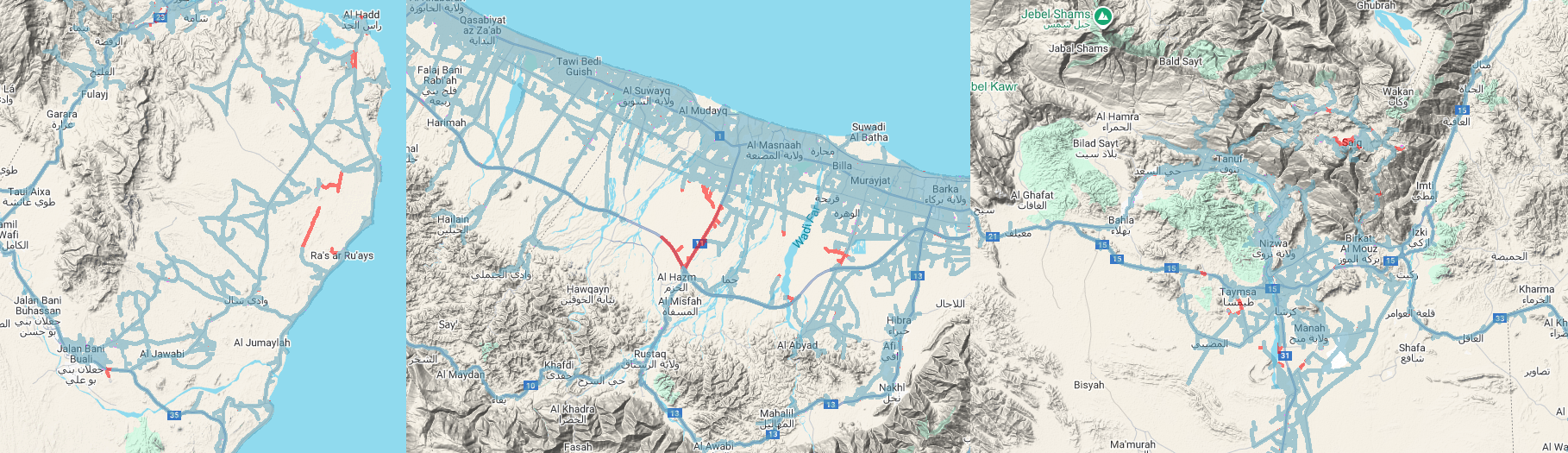
In early December 2024, Google began to remove coverage from certain areas in Oman, specifically around Regional Airports such as Mussanah Airport located in Rustaq, Al Batinah in addition to Ras Al Hadd Airport in Ash Sharqiyah. Furthermore, some roads leading to the Ibri Airport in Ad Dhahirah Governorate were eliminated in this update.
In addition, certain photographs in the locality of Saiq, located in the mountainous region of the governorate of Ad Dakhiliyah, were also deleted. Other coverage eliminated in this governorate also includes some roads connecting Taymsa.
History
Note: We take into account the date when the coverage was taken, not the date when it was published.
| Year | Additions |
|---|---|
| 2024 |
|
Gallery
Gen 4 Cameras
Note: Thanks to @Famous3rbe for providing the photo of the Gen 4 Pickup in Sohar.


References
It's happening! Google Street View will soon cover Oman (2024-02-29) Times of Oman
Explore Oman virtually through Google Street View soon (2024-03-02) Muscat Daily
Al Shidhani, A. (2024-11-16) "قصة النجاح بجذب استثمار عالمي في اشباه الموصلات الى السلطنة" [Translation: The success story of attracting global semiconductor investment to the Sultanate] @embasssssy via Instagram (in Arabic)


